NASA’s EMIT Instrument Tracks and Shares Data on Potent Methane Emissions Globally
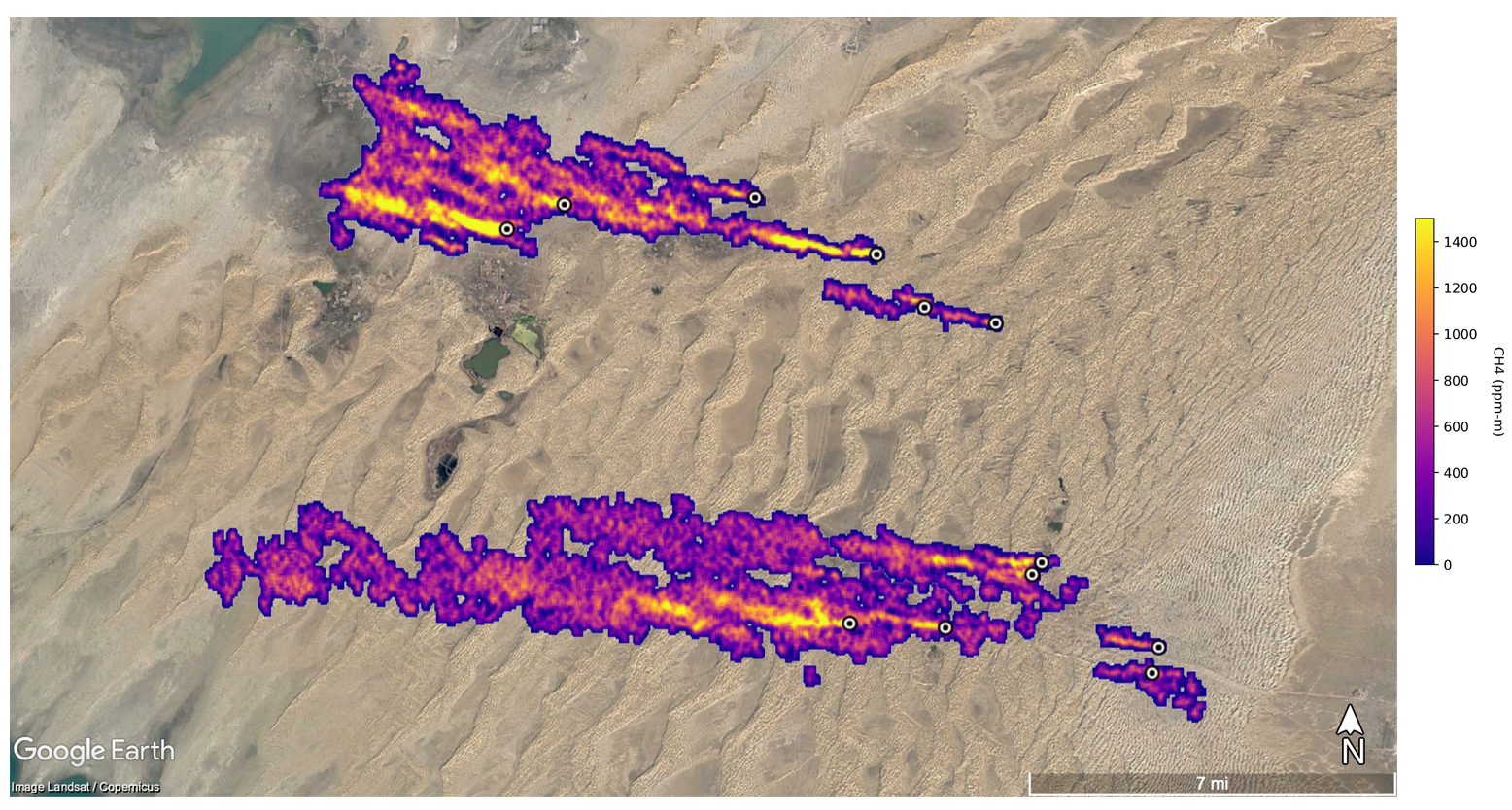 EMIT captured data on 12 methane plumes over 20 miles long in Turkmenistan. Combined, these “super-emitters” release methane at a similar rate to the largest natural gas leak in U.S. history. Credit: NASA/JPL-Caltech
 ![]() One of NASA’s newest instruments on the International Space Station (ISS) is proving to be a multipurpose climate research tool as it demonstrated a secondary capability to detect methane gas emissions.
One of NASA’s newest instruments on the International Space Station (ISS) is proving to be a multipurpose climate research tool as it demonstrated a secondary capability to detect methane gas emissions.
The Earth Surface Mineral Dust Source Investigation (EMIT) mission seeks to better understand varieties of dust and the effects on the climate. The instrument, launched to the space station in July, is an imaging spectrometer that gathers data to determine the mineral compositions of arid regions on Earth.
A few weeks after NASA’s Jet Propulsion Laboratory (JPL) released the first mineral maps created from EMIT data, it announced that the instrument also was successful in identifying locations of methane gas “super-emitters”. Robert Green, principal investigator for EMIT at JPL, explained in a NASA teleconference on Oct. 25 that the 285 wavelengths necessary to determine mineral compositions overlap those used to identify key greenhouse gasses.
“It turns out that methane also has a spectral signature in the same wavelength range, and that’s what has allowed us to be sensitive to methane,” he said.
Methane isn’t as prominent in the atmosphere as carbon dioxide, but its potency means it’s responsible for a fifth of today’s global warming. It also stays in the atmosphere for a shorter time than carbon dioxide, so finding and mitigating methane emissions can have a more immediate impact on climate change.
EMIT can detect the size and concentration of methane plumes in the atmosphere, which allows investigators to determine which points on the ground are emitting the greenhouse gas. The data from EMIT identified more than 50 methane emitters ranging from oil and gas producers to landfills.
One EMIT image from Turkmenistan captured 12 separate emitters producing methane plumes over 20 miles long. Initial estimates for this group place the rate of emissions around 50 metric tons of methane per hour, which is a similar rate to the Aliso Canyon gas leak in 2015 – the largest leak in U.S. history.
While EMIT’s primary mission focuses on specific arid regions, its location on the ISS gives the instrument access to more than 90% of Earth’s inhabited surface. This range could help the secondary mission map methane emissions across most of the world. EMIT can also capture multiple plume observations over the same location at different times of day because the station completes an orbit every 90 minutes.
The EMIT Open Data Portal is part of NASA and JPL’s practice of sharing information through the Open Science and Open Data policy.
– Zoe Hobbs, zhobbs@spacefoundation.org